The Small Concrete Marker Beside a Quiet Trail: Exploring the History of Forgotten Roads
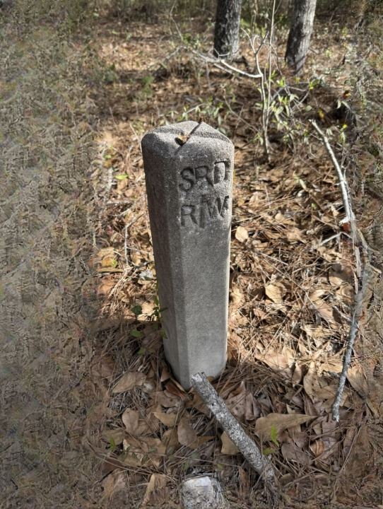
Some of the most interesting clues to local history are easy to overlook. They may be hidden beside a woodland path, partly covered by leaves, or standing quietly at the edge of an old road. Unlike large monuments or clearly marked historic sites, these small objects rarely attract much attention. Yet a simple concrete marker can raise fascinating questions about how a landscape was once used and how communities changed over time.
Imagine walking along a peaceful trail surrounded by trees and vegetation. The route appears ordinary, with compacted earth, scattered stones, and branches extending over the path. Then, beside the trail, you notice a small concrete structure. It may look like an unremarkable block at first, but its position and appearance make you wonder why someone placed it there.
Could it have marked the edge of an old road? Was it once used to identify a boundary, guide travelers, or support a piece of infrastructure? Perhaps it belonged to a route that no longer appears on modern maps.
Without clear inscriptions, historical records, or other supporting evidence, it is impossible to identify a marker confidently from its appearance alone. Nevertheless, objects like these can provide useful starting points for exploring the history of roads, trails, property boundaries, and everyday transportation.
A small concrete object may not reveal an entire story by itself, but it can encourage a closer look at the places people have traveled and the traces they have left behind.
Why Small Objects Can Tell Important Stories
When people think about local history, they often imagine castles, old railway stations, historic buildings, bridges, or monuments. These places are easier to recognize because they tend to be large, distinctive, and sometimes protected by preservation organizations.
However, much of the history of everyday life survives in less obvious forms.
Old roadbeds, stone walls, drainage channels, boundary markers, abandoned foundations, and small concrete posts can all provide clues about how an area developed. Some objects were installed for practical reasons and never intended to become historical landmarks. Others were part of systems that have since been replaced or forgotten.
A marker beside a path may appear insignificant because its original purpose is no longer obvious. The road it once served might have been widened, rerouted, or abandoned. A nearby settlement may have changed, or modern transportation may have made the original route unnecessary.
Over time, vegetation can cover the surrounding landscape, while erosion and weather gradually alter the object’s appearance. As a result, something that once had a clear practical function may become a mystery to people passing by.
This is one reason local history can be so rewarding. Instead of beginning with a famous event, an investigation can start with a small physical clue and gradually build a broader understanding of the area.
Could the Marker Belong to an Old Road?
One possible explanation for a concrete marker beside a trail is that it was associated with a road or transportation route.
Roads have always required some form of organization. Depending on the period and location, workers and authorities have used physical markers to identify distances, boundaries, directions, maintenance areas, or particular sections of a route.
Some markers were designed to be visible to travelers. Others served a more practical purpose, helping surveyors, maintenance crews, engineers, or landowners identify specific locations.
When a road is abandoned or altered, its associated markers may remain in place long after the original route disappears from everyday use.
For example, a former road might have connected a small settlement to a nearby market, farm, mill, railway station, or main transportation corridor. If a newer road eventually provided a more convenient connection, the older route might have received less traffic and gradually become overgrown.
The remaining path could still follow parts of the original alignment. A person walking through the area might recognize a relatively straight section, a raised embankment, a shallow cutting, or a surface containing compacted gravel.
However, none of these features proves that a route was historically a public road. Paths can develop through repeated foot traffic, forestry work, agricultural activity, private access, or modern recreational use.
Likewise, a concrete marker does not automatically indicate that the nearby path is old. The object might have been installed more recently for a purpose unrelated to transportation.
The most reliable way to investigate the possibility is to compare the physical landscape with historical maps, local records, and other evidence.
How Roads Change Over Time
Road networks rarely remain unchanged for long periods. Communities grow, industries develop, transport technology changes, and routes are adjusted to meet new needs.
A road that was once essential may become less important after a railway opens nearby. A bridge replacement might redirect traffic away from an older crossing. A new highway may bypass a village, leaving an earlier route with only local use.
Changes in land ownership can also affect transportation. A route that once crossed open fields might become a private access road after a property is divided or sold. Agricultural changes may eliminate a track that previously connected several farms.
In wooded areas, former roads can be especially difficult to recognize. Trees may grow along the route, roots may disturb the surface, and leaves may accumulate over the old roadway. Water flowing across the ground can wash away loose material and soften the edges of the route.
In other cases, the route remains surprisingly clear. The ground may be flatter than the surrounding terrain, or the path may follow a consistent width through the trees.
Small remnants can help researchers identify these changes. A drainage structure, old retaining wall, surviving signpost, or concrete marker may offer a clue about how the route was designed or maintained.
Still, interpreting such evidence requires caution. The landscape can preserve traces of several different periods, and features that appear connected may have been created decades apart.
What Exactly Is a Concrete Marker?
Concrete markers come in many shapes and sizes. Their function depends on their design, placement, markings, and surrounding environment.
A simple rectangular block might be a boundary marker, while a narrow post could have supported a sign or identified a particular location. A low concrete structure might be associated with drainage, surveying, utilities, or a former road installation.
Some markers contain numbers, letters, dates, symbols, or other inscriptions. These details can be particularly helpful because they may connect the object to a specific organization, infrastructure system, or period.
Other markers are plain. They may have lost their original identifying features through weathering, damage, or the removal of attached equipment.
The material itself is not enough to establish an object’s age. Concrete has been used in infrastructure for a long time, and a weathered appearance does not provide a dependable date. Surface discoloration, moss, cracks, and chipped edges can develop under many different conditions.
Even the object’s location can be misleading. A marker beside a trail may have originally stood beside a different route that was later moved or narrowed. Alternatively, the trail may have developed around an existing structure.
For a careful investigation, researchers typically consider several characteristics together: shape, dimensions, construction, inscriptions, position, and the history of the surrounding land.
The goal is not simply to find a plausible explanation, but to determine which explanation is best supported by the evidence.
The Importance of Historical Maps
Historical maps are among the most useful resources for investigating an unfamiliar feature in the landscape.
Maps produced for different purposes can show roads, property boundaries, settlements, waterways, railway lines, buildings, and other features. Comparing editions from different years may reveal when a route first appeared or when its importance began to change.
For example, an older map might show a road crossing an area where a modern map displays only woodland. A later edition might show the road shortened or redirected. That difference could provide a starting point for understanding why a surviving path follows a particular alignment.
Maps can also help distinguish between possible types of routes. A line shown as a public road may have a different historical significance from a footpath, farm track, or private access route.
Nevertheless, old maps are not perfect records of every feature. Some were created for military planning, property administration, transportation, or other specialized purposes. Their level of detail varies, and small paths may be omitted.
Mapmakers may also have used different symbols or naming conventions. A route could appear under a different name, or the map might show a road without explaining its ownership or intended use.
The best approach is to compare several sources rather than relying on one map. Historical maps, aerial photographs, local archives, and modern geographic information can sometimes provide complementary evidence.
Aerial Photographs Can Reveal Hidden Routes
Aerial photographs offer another way to study landscapes that have changed over time.
From above, former roads and tracks may appear as lines of different vegetation, subtle changes in ground color, or long, narrow clearings. Even when a route is difficult to see from the ground, its shape may become more apparent in an aerial image.
Older aerial photographs can be especially useful because they document the landscape before later development or vegetation growth altered its appearance.
Aerial imagery may help researchers identify where a route entered a field, crossed a stream, connected to a settlement, or continued into a wooded area.
In some places, a former road may survive as a raised strip of land or a shallow depression. These features can be easier to recognize when the landscape is viewed from a different angle.
However, aerial photographs also have limitations. Shadows, seasonal vegetation, agricultural patterns, and modern land use can create lines that resemble old roads. A visible feature may be natural rather than human-made, or it may belong to a much more recent activity.
For that reason, aerial evidence should be compared with maps and observations on the ground.
When several independent sources point toward the same explanation, confidence in the interpretation can increase.
Surveying and Property Boundaries
Not every concrete marker near a path was intended to guide travelers. Some objects were installed to identify property boundaries or assist with land surveying.
Surveyors use reference points and measurements to establish the positions of boundaries, buildings, roads, and other features. Depending on the jurisdiction and the purpose of the survey, a marker may be placed at a corner, along a boundary, or at another significant location.
Such markers can remain in place for many years because moving or removing them may create confusion about property limits.
A boundary marker may appear beside a trail simply because the route follows the edge of a parcel of land. The apparent connection between the marker and the path might therefore be incidental rather than evidence that the object belonged to an old road.
In some locations, survey markers are small metal pins or stones. In others, concrete posts or blocks may be used, depending on local practices and the period when the survey was carried out.
A marker’s position relative to fences, walls, field edges, and property lines may help explain its purpose. But these features should not be treated as definitive proof without supporting records.
Anyone investigating a possible boundary marker should avoid moving it or assuming that it indicates a legal property line. Property boundaries can be complex, and official survey records are the appropriate source for confirming them.
Markers Associated With Utilities and Infrastructure
Concrete structures are also commonly used in infrastructure systems that may be difficult to recognize after their original function has disappeared.
An object beside a path might be related to a drainage system, water supply, telecommunications installation, electricity infrastructure, or another utility. Some installations include concrete supports or protective structures that remain after equipment has been removed.
Road construction can also leave behind drainage channels, culvert entrances, retaining structures, and foundations for signs or barriers.
If a marker is near a stream, ditch, bridge, or embankment, its position may be relevant to understanding its purpose. A low concrete feature near a road could be associated with water management rather than navigation.
Similarly, a post beside a former railway alignment might have served an infrastructure-related function rather than marking a road.
These possibilities demonstrate why an object should be studied within its surroundings. A photograph of the marker alone may not provide enough information to distinguish between several explanations.
It is also important to avoid touching or disturbing unfamiliar structures. A feature that appears abandoned could still be connected to active utilities or located near equipment that presents a safety risk.
Observation from a safe distance is generally the best first step.
Why Some Historic Features Are Never Officially Recorded
Not every historical object appears in a museum catalogue or heritage database.
Many structures were created for ordinary practical purposes rather than as landmarks. They may have been installed by local authorities, private landowners, utility companies, transportation departments, or contractors.
If the original records are lost or incomplete, later generations may have little information about the object’s purpose.
Small routes can also disappear from official attention when they no longer serve a major transportation function. A private track might be removed from a road inventory, while a former maintenance route may become overgrown without receiving a formal historical designation.
Local knowledge can sometimes preserve information that is missing from written records. Residents may remember an old road, a former bridge, a field boundary, or a route used by previous generations.
Oral history can be valuable, especially when several accounts describe the same feature. However, memories can change over time, and people may interpret an object differently depending on what they have heard.
The strongest investigations combine local recollections with physical evidence and documentary sources.
A small marker may not be officially recognized as historically significant, but that does not mean it lacks value as a clue to the development of the area.
How Local Historians Investigate a Discovery
A careful investigation often begins with simple observations.
The researcher records where the object is located, how it is positioned, what it looks like, and which landscape features are nearby. Photographs taken from several angles can help document the object’s shape and condition.
If there are visible inscriptions, they may be photographed without scraping, cleaning, or otherwise altering the surface.
The next step is to consider possible explanations. Is the object close to an old road alignment? Does it appear to mark a corner or boundary? Is there evidence of drainage, a former structure, or another infrastructure feature nearby?
These are working questions rather than conclusions.
Researchers can then compare the observations with historical maps, archival photographs, property records, transportation documents, and local histories.
A local library, historical society, museum, municipal archive, or heritage organization may have information about former roads and land use. In some areas, official geographic information systems provide historical mapping layers or records of public rights of way.
The investigation may also benefit from speaking with people who know the area, particularly when they can identify former landmarks or explain changes in local routes.
Throughout the process, it is important to record uncertainty. If the evidence suggests that a marker could be related to a former road but does not prove the connection, that distinction should remain clear.
A responsible historical account does not need to offer a dramatic answer. Sometimes the most useful result is a better understanding of what is known, what remains uncertain, and which records might resolve the question.
The Role of Local Communities in Preserving History
Local residents often play an important role in recognizing and preserving overlooked historical features.
People who regularly walk through an area may notice changes that occasional visitors miss. They may know where an old route once ran, remember a building that no longer exists, or have heard stories about how a particular section of land was used.
Community history projects can collect these memories and compare them with maps and photographs. When properly documented, the information can help preserve knowledge that might otherwise disappear as older residents move away or pass on.
Schools, local museums, walking groups, and historical societies sometimes organize projects that document old roads, landmarks, and changes in settlement patterns.
These activities can also help people develop a stronger understanding of the landscape around them. A familiar trail may become more interesting when its relationship to former farms, transport routes, or community boundaries is understood.
However, preservation work should respect land ownership, privacy, and environmental protections. Discovering an object does not automatically grant permission to enter private land, excavate the area, or remove material.
Where an object may be historically significant, documenting it and contacting an appropriate local organization is often more useful than attempting to collect it.
Why Forgotten Roads Matter
Old roads can reveal much more than how people moved from one place to another.
Their locations may reflect the geography of settlement, the availability of water, the position of markets, the development of agriculture, and the relationship between neighboring communities.
A road might have connected a village to a mill, linked farms to a market town, or provided access to a railway station. Another might have been used by workers traveling to an industrial site or by residents reaching schools, shops, and public services.
As communities changed, the importance of individual routes changed as well. Some roads became major transportation corridors, while others lost their original purpose.
Studying these changes can help explain why settlements developed where they did and how people adapted to economic and technological developments.
The remains of an old road may also preserve information about construction methods. Embankments, stone surfaces, drainage features, and retaining walls can offer clues about the engineering challenges faced by earlier builders.
Even a route that seems insignificant today may have once been important to the people who used it.
A concrete marker beside a path can therefore serve as a reminder that modern landscapes are built upon layers of earlier activity.
Weather, Vegetation, and the Passage of Time
Natural processes can gradually obscure evidence of past human activity.
Rain can wash soil onto a path, while streams may erode the edges of old roadbeds. Fallen leaves accumulate in depressions, and roots can lift or break apart surfaces.
In wooded areas, vegetation may grow over former routes until they are difficult to distinguish from the surrounding ground.
Concrete generally lasts longer than many organic materials, but it is not immune to weathering. Changes in temperature, moisture, soil conditions, and exposure can contribute to cracking, surface deterioration, and discoloration.
Moss and lichen may grow on exposed surfaces, making an object blend into the environment. These growths can give a marker an aged appearance, but they cannot establish a precise date.
The landscape can also change because of human activity. Forestry operations, farming, construction, and the rerouting of paths may alter the relationship between a surviving marker and the route it originally served.
This is why the present-day appearance of an object should not be treated as a complete record of its history. Understanding the past often requires reconstructing how the surrounding landscape looked at different points in time.
How to Explore Historic Trails Responsibly
For people interested in local history, walking an old trail can be an enjoyable way to learn about the landscape.
A responsible visit begins with checking whether the route is open to the public. Some paths cross private property or protected land, and access rules may differ from one area to another.
Visitors should stay on permitted routes, avoid damaging vegetation, and leave objects where they are found.
If a marker appears unusual, photographs and notes can document it without disturbing the site. A photograph showing the surrounding landscape may be more useful than a close-up alone because it helps establish the object’s position in relation to the trail.
It is also wise to avoid digging around the object, removing plants, or attempting to clean inscriptions. These actions can damage evidence or create unnecessary safety risks.
Where there is a possibility that the marker is connected to utilities, road infrastructure, or a property boundary, it should be treated with additional caution.
If the object appears to have historical significance, a local heritage organization or relevant public authority may be able to advise on appropriate next steps.
Responsible exploration allows people to learn about the past while helping ensure that the evidence remains available for others.
Separating Evidence From Speculation
The mystery surrounding an unfamiliar object can be part of its appeal. A small marker beside a quiet path naturally invites questions about its origin and purpose.
But curiosity should not be confused with proof.
A concrete block does not establish that a road once existed, and an overgrown path does not automatically date to a particular historical period. Several explanations may fit the initial observations.
Reliable conclusions require evidence that connects the object to a specific function or historical setting. This might include an inscription, an archival photograph, an engineering drawing, a map, a property record, or documentation from a relevant authority.
Even when evidence is available, conclusions should reflect its limits. A map may confirm that a road existed in the area without proving that a particular marker belonged to it.
Similarly, a local story may suggest a possible explanation without establishing the object’s original use.
Careful language helps readers distinguish between confirmed facts and reasonable possibilities. Phrases such as “may have marked,” “could be associated with,” and “requires further investigation” are appropriate when the evidence remains incomplete.
This approach does not make the story less interesting. Instead, it allows the discovery to become the starting point for a genuine investigation rather than a conclusion based on assumptions.
A Small Marker and a Larger Historical Picture
A quiet path can contain clues to a landscape’s changing identity. The route may follow an old transportation corridor, cross land that was once farmed, or connect places that developed around a different pattern of movement.
A concrete marker beside the path may be connected to one of these histories, but its precise purpose cannot be established without more information about the object and its location.
What makes such a discovery valuable is the opportunity to ask better questions.
Historical maps can show how routes changed. Aerial photographs can reveal traces that are difficult to see from the ground. Local records may identify former infrastructure, while residents can contribute memories of places that have changed over time.
When these sources are compared carefully, an ordinary object can help researchers understand how a community developed and how its landscape was transformed.
The investigation may reveal that the marker belonged to an old road. It may instead turn out to be a survey point, a drainage feature, or a more recent installation. Either outcome can contribute to a clearer understanding of the area.
Conclusion: Looking More Closely at Everyday History
The small concrete marker beside a quiet trail illustrates how easily traces of the past can blend into an ordinary landscape. Objects that once served a practical purpose may remain long after the routes, buildings, or systems associated with them have changed.
Although the exact identity of an individual marker cannot be determined from a brief description alone, its presence can encourage a meaningful exploration of local history.
Forgotten roads, boundary markers, drainage structures, and other modest remnants provide clues about how people traveled, worked, managed land, and adapted to changing circumstances.
The most reliable way to understand such a feature is to examine its physical characteristics, study the surrounding landscape, consult historical records, and compare different sources of evidence.
For anyone who enjoys exploring the outdoors, this offers a simple lesson: a familiar path may contain more history than first appears. Taking time to observe the details can reveal new questions about the places we pass every day.
Sometimes, the value of a discovery lies not in an immediate answer but in the investigation it inspires. A small concrete object may seem ordinary, yet it can become a starting point for understanding the many layers of history preserved in the landscape.