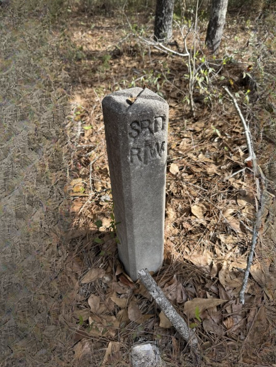
What’s Hiding Beside This Quiet Path? The Small Concrete Marker That May Reveal a Forgotten Road and Local History
Sometimes the most fascinating discoveries are not towering monuments, famous landmarks, or objects displayed behind glass in a museum. Instead, they are small, ordinary-looking features that have remained unnoticed for decades, quietly preserving clues about the past.
Imagine walking along a narrow trail through a wooded area. The path beneath your feet appears to be little more than dirt, gravel, and fallen leaves. Trees lean over the route, birds call from somewhere in the distance, and the surrounding landscape seems unchanged by modern life.
Then something catches your eye.
Beside the trail, partially hidden by grass and low vegetation, sits a small concrete marker. It is weathered and discolored, with rough edges that suggest it has been exposed to rain, frost, and sunlight for many years. Perhaps a few faded marks are visible on its surface. Perhaps it appears to have been placed deliberately beside the path.
At first, the object seems insignificant.
But why is it there?
Could it mark the boundary of an old property? Was it once used to identify a road, a utility line, or a piece of public infrastructure? Could it be a remnant of a route that disappeared when the surrounding area changed?
Without additional evidence, it is impossible to identify a particular marker from a short description alone. Nevertheless, small concrete objects like this can provide useful starting points for exploring local history, especially when they are examined alongside old maps, historical photographs, and records of how a landscape developed.
What appears to be an unremarkable piece of concrete may have a practical explanation—and that explanation can reveal something interesting about the place where it was found.
The Small Object That Makes You Stop Walking
One of the pleasures of exploring older trails is discovering features that do not immediately fit the surrounding landscape.
A stone wall may run through a forest where no houses remain. A shallow depression may follow a straight line through otherwise uneven ground. An abandoned bridge may stand beside a stream that no longer carries regular traffic.
Sometimes, the clues are even smaller.
A short concrete post, a metal fitting, a line of bricks, or a fragment of an old sign can suggest that the area once served a purpose different from the one it serves today.
The natural world gradually covers human-made structures. Grass grows over foundations, tree roots spread across old surfaces, and soil accumulates in places where people once walked or drove. Over time, an area can appear entirely natural even when traces of earlier activity remain close to the surface.
This process is one reason historical features can be easy to overlook.
A concrete marker may not attract attention from someone walking quickly through the area. Someone who pauses to examine the surroundings, however, may notice that its position seems deliberate.
Is it aligned with the trail? Does it stand near a bend? Is there a similar object farther along the route? Does the path follow a straight line that seems unusual for the terrain?
These observations do not establish what the marker was used for, but they help turn curiosity into a more useful investigation.
The first step is not to guess its identity.
It is to observe the evidence carefully.
Why Concrete Markers Were Used in the Past
Concrete became an important construction material because it can be shaped into durable forms and used for a wide variety of purposes. Its strength, versatility, and relative practicality made it useful for roads, buildings, drainage systems, property improvements, and public infrastructure.
Small concrete markers can serve many functions.
Some identify boundaries. Others indicate distances, underground services, survey points, or the locations of structures. Certain markers are associated with roads, railways, water systems, and electrical infrastructure.
Their appearance can vary considerably according to their age, location, and intended use.
A marker may be a simple rectangular post, a short block set into the ground, or a shaped object carrying numbers, letters, symbols, or a small metal plate. Some were designed to be highly visible, while others were intended primarily for workers familiar with the system.
A weathered marker beside an old path could therefore have several possible explanations.
It might be connected to a former road, but it could also belong to a boundary survey, a drainage project, a water pipeline, or another form of infrastructure.
The material alone cannot reveal its purpose.
Even an inscription, if one exists, may require local knowledge to interpret correctly. Abbreviations and numbering systems often make sense only when compared with records from the organization that installed them.
That is why the location and surrounding landscape matter just as much as the marker itself.
Could It Be a Remnant of an Old Road?
One possibility worth investigating is whether the path follows a former road or track.
Roads do not always disappear completely when they stop being used. In rural areas, older routes may be abandoned after a new road is built, a bridge becomes unusable, a settlement changes, or transportation patterns shift.
The old route may remain visible as a narrow strip through the vegetation.
In other cases, only subtle traces survive.
A line of unusually level ground may cross a slope. A shallow embankment may continue through a wooded area. Two sections of modern road may appear to point toward one another even though a direct connection no longer exists.
Old maps can help explain these features.
A route that appears on a historical map but is missing from modern maps may indicate that the road was closed, rerouted, renamed, or absorbed into another property. Comparing maps from different periods can reveal how transportation networks developed over time.
However, a path should not automatically be described as a forgotten road simply because it looks old.
Footpaths, animal tracks, forestry routes, utility access paths, and modern recreational trails can resemble abandoned roads. A concrete marker beside one of these routes may have nothing to do with transportation.
To establish a connection, researchers would need supporting evidence such as historical maps, road records, surviving road surfaces, dated photographs, or documentation from a local authority.
Even when the original road cannot be identified, investigating the surrounding landscape can still reveal how the area was used in the past.
How an Old Road Can Disappear From the Landscape
The history of a road is often a story of gradual change rather than a single dramatic event.
A route may originally have connected farms, villages, mills, markets, or neighboring settlements. It could have been used by pedestrians, carts, livestock, and later motor vehicles.
As communities expanded and transportation improved, the original route might have become less convenient.
A new road could offer a shorter journey. A bridge might provide a safer crossing. A growing settlement might require wider streets or a different traffic pattern.
When an alternative route becomes more practical, an older road may lose its importance.
Sometimes the old route remains in use as a footpath or agricultural track. In other cases, it is absorbed into private land, blocked by vegetation, or divided by new development.
The physical evidence can survive long after the original purpose has been forgotten.
Road surfaces may remain under soil and vegetation. Stone drainage channels may continue to direct water along the former route. Small structures may survive beside the track because removing them would serve no practical purpose.
Concrete markers are particularly interesting because they can remain in place even after the system they once supported has changed.
Yet identifying their exact role requires care. A marker that appears to stand beside an old road may have been installed much later for a completely different reason.
The surrounding history must be considered before reaching a conclusion.
Other Possible Explanations for a Small Concrete Marker
Although an old road is an intriguing possibility, several other explanations should be considered.
1. A Property or Land-Boundary Marker
Land boundaries have long been marked using stones, posts, walls, and other permanent features.
A concrete marker may indicate a surveyed corner, a dividing line, or a reference point used in land records.
These markers can be particularly common where property boundaries meet roads, forests, agricultural fields, or other recognizable landscape features.
If the object stands near a change in land use or appears to line up with other markers, a boundary-related purpose may be worth investigating.
However, the precise legal significance of a marker cannot be established simply by looking at it. Official cadastral maps and survey records are generally needed to determine whether it corresponds to a registered boundary.
2. A Surveying Reference Point
Surveyors use reference points to establish or verify locations, elevations, and measurements.
Depending on the system, these points may be marked by metal fittings, concrete blocks, posts, or other durable objects.
A marker of this type might appear unremarkable to the casual observer, yet it could have been important for measuring land or constructing infrastructure.
Its location may be related to a wider surveying network rather than to the path beside it.
Survey records, local mapping information, and visible markings may help clarify its purpose.
Because some survey markers remain relevant to modern measurements, disturbing them can destroy useful information.
3. A Utility or Infrastructure Marker
Water pipes, drainage systems, electrical installations, telecommunications equipment, and other utilities can leave small markers at the surface.
Some indicate the approximate position of underground infrastructure. Others identify access points, service routes, or features needed for maintenance.
An old concrete marker could therefore relate to a system that is no longer visible from the surface.
A nearby manhole, drainage channel, pole, valve cover, or line of similar markers may provide additional clues.
Nevertheless, underground services cannot be identified safely by appearance alone. Anyone planning excavation or construction should consult the appropriate utility records and follow local safety procedures.
4. A Boundary Between Different Types of Land
Some markers distinguish public land from private property or identify the limits of a managed area.
A marker in a forest, for example, could be associated with land administration, forestry operations, or a conservation boundary.
The relevant rules depend on the location and the organization responsible for the land.
If the marker stands near a trail entrance, a change in vegetation management, or a boundary fence, these details may provide useful context.
Even so, it should not be assumed that an unmarked concrete post indicates where public access ends.
Official signs, property records, and guidance from the responsible authority are more reliable sources of information.
5. A Remnant of a Former Building or Industrial Site
Small concrete blocks may once have supported fences, machinery, signposts, lighting equipment, or other structures.
If the surrounding area contains foundations, brick fragments, old metal fittings, or unusual ground depressions, the marker may be part of a larger site.
Industrial activity, agriculture, forestry, and transportation can all leave traces that become difficult to recognize as the landscape changes.
A local historical society or heritage specialist may be able to help interpret these clues.
The key is to look for patterns rather than assuming that a single object tells the whole story.
How to Investigate the Marker Without Disturbing It
Finding a potentially historical object can make people eager to uncover its identity. Fortunately, much of the initial investigation can be completed without moving, digging around, or damaging anything.
A careful approach preserves the evidence and reduces the chance of disturbing a legally protected feature or an active utility installation.
Step 1: Record the Exact Location
Begin by noting where the marker was found.
A map pin or GPS coordinate can be useful, provided that recording the location is safe and lawful. Include a description of the nearest trail, stream, bridge, road, or other recognizable feature.
The location may eventually prove more informative than the object’s appearance.
For example, a marker that lies in a straight line with several other structures may suggest a different purpose from one located at an isolated bend.
Avoid sharing the exact location publicly if the site appears vulnerable to vandalism, unauthorized excavation, or damage.
Step 2: Photograph the Object From Different Angles
Take clear photographs from a respectful distance.
Useful views include:
- The marker in its surrounding landscape.
- A closer view showing its shape and surface.
- Any visible numbers, letters, symbols, or metal fittings.
- Nearby features that may help explain its function.
- Other similar markers, if they are visible without leaving an authorized path.
Include an object of known size in a photograph only if doing so does not require touching or placing anything on the marker.
Do not scrape away moss, clean the surface with chemicals, or attempt to expose hidden inscriptions. Even seemingly harmless cleaning can damage a fragile surface or remove evidence.
Step 3: Look for Similar Features Nearby
Observe whether the marker is part of a larger pattern.
Are there other concrete posts at regular intervals? Does a line of stones follow the same direction? Is there a visible embankment or drainage channel nearby?
A repeated pattern can provide stronger clues than an isolated object.
However, do not leave a permitted trail, cross fences, or enter restricted land to look for additional features.
The investigation should remain within the boundaries of lawful and safe access.
Step 4: Compare Historical and Modern Maps
Historical maps can help identify roads, settlements, boundaries, and infrastructure that no longer appear on current maps.
Depending on the region, useful resources may include national mapping agencies, municipal archives, historical libraries, land registries, and local heritage collections.
Compare maps from different dates and look for routes that once crossed the area.
Pay attention to changes in place names, road alignments, bridges, property boundaries, and nearby buildings.
A map may reveal that a route once continued through the area, but it will not necessarily identify the concrete marker itself. That connection still requires corroboration.
Step 5: Ask Local Historians or Land Managers
People who have researched a region for years may recognize features that are unfamiliar to newcomers.
Local historical societies, museums, archivists, forestry departments, land managers, and municipal offices may hold relevant information.
When asking for help, provide a concise description, the approximate location, and a few photographs.
Rather than stating that the object is definitely an old road marker, explain that you are trying to identify it and ask whether any records might clarify its purpose.
This encourages a more accurate answer and avoids allowing an early guess to become accepted as fact.
Why Historical Maps Can Reveal More Than Expected
Maps are among the most valuable tools for understanding how a landscape changes.
A modern map shows the present arrangement of roads, buildings, waterways, and property features. A historical map can show how those elements were organized decades or even centuries earlier.
When maps from different periods are compared, the changes can be surprisingly revealing.
A road th